


Le Hohneck 2012

raphpieters
User
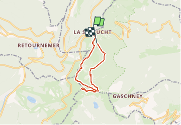

Length
10 km

Max alt
1355 m

Uphill gradient
533 m
Km-Effort
17.2 km

Min alt
985 m

Downhill gradient
572 m
Boucle
No
Creation date :
2014-12-10 00:00:00.0
Updated on :
2014-12-10 00:00:00.0
6h18
Difficulty : Medium

FREE GPS app for hiking
 SityTrail
IGN / Geographical institutes
SityTrail Plus
The world is yours!
About
Trail Other activity of 10 km to be discovered at Grand Est, Vosges, Le Valtin. This trail is proposed by raphpieters.
Positioning
Country:
France
Region :
Grand Est
Department/Province :
Vosges
Municipality :
Le Valtin
Location:
Unknown
Start:(Dec)
Start:(UTM)
352664 ; 5325229 (32U) N.
Comments